Return to flip book view
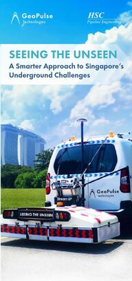
Message Why ChooseProven Track RecordOur ServicesContact UsProfessional TeamCutting-edge EquipmentsGeoPulse Technologies?Scanned 2.6+ million m² of Singapore’s roads and turf, mastering local underground complexities.Expert in-house GPR analysts and drafters. Rigorous QA ensures precise data interpretation.· Utility Mapping using MCGPR and EML· Geo-Located Combined Utility Plan (Geo-CUP)· Geo-located Point Cloud (GPC) Survey· Compliance to URA IPAG Workflow· Void Detection, Water Leak Detection, Anomalies Check, Concrete Scanning & Rebar Detection, LCDW and TCDW for NCE applications, Topographical SurveyGeoPulse transforms subsurface utility detection with advanced non-invasive technologies to deliver accurate, real-time insights into underground conditions. It helps to minimise costly surprises, project delays, and enhance overall safety.2,600,000+ m² A Smarter Approach to Singapore’s Underground ChallengesSEEING THE UNSEENVehicle-mounted MCGPR for rapid large-scale surveysPush-cart MCGPR for versatile terrain (pavement, turf, uneven ground)Flip to find out38 Senoko Road, Singapore 758110+65 9644 4031admin@geopulse.sgwww.geopulse.sg
In today’s digital construction era, precision and efficiency are crucial. Traditional trial trenching methods can no longer keep up with the demands of modern infrastructure projects. Urban underground spaces are densely packed with utilities, complicating construction.Traditional trial trenching is expensive, slow, and offers limited visibility.Inaccurate utility detection leads to delays, budget overruns, and safety hazards.Disruptions caused by unknown services increase costs & extend timelines significantly.Multi-Channel Ground Penetrating Radar (MCGPR) and Electromagnetic Locators (EML) are powerful technologies that enhance subsurface mapping by providing accurate and efficient detection of underground utilities. Technology· Multiple radar antennas for high-resolution, subsurface imaging.· Deeper penetration and wider coverage vs. traditional GPR.Strengths· Provide detailed visualisation of buried utilities.· Detects pipes, cables, voids in congested environments.· Minimizes excavation risks with real-time, non-invasive mapping.· Provide comprehensive, non-invasive mapping solution.· Development of Geo-located Combined Utiility Plan (Geo-Cup).· Giving geo-referenced utility location.· Delivering accurate underground data before construction begins.· Minimizes excavation risks, reduces project delays.Technology· Using electromagnetic signals to pinpoint conductive utilities (metal pipes, electrical cables).Strengths· Active and Passive Detection to deliver accurate utility location.· Complements MCGPR to detect conductive material.Complex Urban UndergroundGeoPulse SolutionsMulti-Channel Ground Penetrating Radar (MCGPR)Electromagnetic Locators (EML)MCGPR + EMLExpensive Trial HolesProject RisksImpact:Modern infrastructure concerns can be solved with our advanced equipmentsNo More Guesswork!Inaccurate Utility As-built DrawingsWhere do you think the utilities are?
In today’s digital construction era, precision and efficiency are crucial. Traditional trial trenching methods can no longer keep up with the demands of modern infrastructure projects. Urban underground spaces are densely packed with utilities, complicating construction.Traditional trial trenching is expensive, slow, and offers limited visibility.Inaccurate utility detection leads to delays, budget overruns, and safety hazards.Disruptions caused by unknown services increase costs & extend timelines significantly.Multi-Channel Ground Penetrating Radar (MCGPR) and Electromagnetic Locators (EML) are powerful technologies that enhance subsurface mapping by providing accurate and efficient detection of underground utilities. Technology· Multiple radar antennas for high-resolution, subsurface imaging.· Deeper penetration and wider coverage vs. traditional GPR.Strengths· Provide detailed visualisation of buried utilities.· Detects pipes, cables, voids in congested environments.· Minimizes excavation risks with real-time, non-invasive mapping.· Provide comprehensive, non-invasive mapping solution.· Development of Geo-located Combined Utiility Plan (Geo-Cup).· Giving geo-referenced utility location.· Delivering accurate underground data before construction begins.· Minimizes excavation risks, reduces project delays.Technology· Using electromagnetic signals to pinpoint conductive utilities (metal pipes, electrical cables).Strengths· Active and Passive Detection to deliver accurate utility location.· Complements MCGPR to detect conductive material.Complex Urban UndergroundGeoPulse SolutionsMulti-Channel Ground Penetrating Radar (MCGPR)Electromagnetic Locators (EML)MCGPR + EMLExpensive Trial HolesProject RisksImpact:Modern infrastructure concerns can be solved with our advanced equipmentsNo More Guesswork!Inaccurate Utility As-built DrawingsWhere do you think the utilities are?
In today’s digital construction era, precision and efficiency are crucial. Traditional trial trenching methods can no longer keep up with the demands of modern infrastructure projects. Urban underground spaces are densely packed with utilities, complicating construction.Traditional trial trenching is expensive, slow, and offers limited visibility.Inaccurate utility detection leads to delays, budget overruns, and safety hazards.Disruptions caused by unknown services increase costs & extend timelines significantly.Multi-Channel Ground Penetrating Radar (MCGPR) and Electromagnetic Locators (EML) are powerful technologies that enhance subsurface mapping by providing accurate and efficient detection of underground utilities. Technology· Multiple radar antennas for high-resolution, subsurface imaging.· Deeper penetration and wider coverage vs. traditional GPR.Strengths· Provide detailed visualisation of buried utilities.· Detects pipes, cables, voids in congested environments.· Minimizes excavation risks with real-time, non-invasive mapping.· Provide comprehensive, non-invasive mapping solution.· Development of Geo-located Combined Utiility Plan (Geo-Cup).· Giving geo-referenced utility location.· Delivering accurate underground data before construction begins.· Minimizes excavation risks, reduces project delays.Technology· Using electromagnetic signals to pinpoint conductive utilities (metal pipes, electrical cables).Strengths· Active and Passive Detection to deliver accurate utility location.· Complements MCGPR to detect conductive material.Complex Urban UndergroundGeoPulse SolutionsMulti-Channel Ground Penetrating Radar (MCGPR)Electromagnetic Locators (EML)MCGPR + EMLExpensive Trial HolesProject RisksImpact:Modern infrastructure concerns can be solved with our advanced equipmentsNo More Guesswork!Inaccurate Utility As-built DrawingsWhere do you think the utilities are?
Why ChooseProven Track RecordOur ServicesContact UsProfessional TeamCutting-edge EquipmentsGeoPulse Technologies?Scanned 2.6+ million m² of Singapore’s roads and turf, mastering local underground complexities.Expert in-house GPR analysts and drafters. Rigorous QA ensures precise data interpretation.· Utility Mapping using MCGPR and EML· Geo-Located Combined Utility Plan (Geo-CUP)· Geo-located Point Cloud (GPC) Survey· Compliance to URA IPAG Workflow· Void Detection, Water Leak Detection, Anomalies Check, Concrete Scanning & Rebar Detection, LCDW and TCDW for NCE applications, Topographical SurveyGeoPulse transforms subsurface utility detection with advanced non-invasive technologies to deliver accurate, real-time insights into underground conditions. It helps to minimise costly surprises, project delays, and enhance overall safety.2,600,000+ m² A Smarter Approach to Singapore’s Underground ChallengesSEEING THE UNSEENVehicle-mounted MCGPR for rapid large-scale surveysPush-cart MCGPR for versatile terrain (pavement, turf, uneven ground)Flip to find out38 Senoko Road, Singapore 758110+65 9644 4031admin@geopulse.sgwww.geopulse.sg
Why ChooseProven Track RecordOur ServicesContact UsProfessional TeamCutting-edge EquipmentsGeoPulse Technologies?Scanned 2.6+ million m² of Singapore’s roads and turf, mastering local underground complexities.Expert in-house GPR analysts and drafters. Rigorous QA ensures precise data interpretation.· Utility Mapping using MCGPR and EML· Geo-Located Combined Utility Plan (Geo-CUP)· Geo-located Point Cloud (GPC) Survey· Compliance to URA IPAG Workflow· Void Detection, Water Leak Detection, Anomalies Check, Concrete Scanning & Rebar Detection, LCDW and TCDW for NCE applications, Topographical SurveyGeoPulse transforms subsurface utility detection with advanced non-invasive technologies to deliver accurate, real-time insights into underground conditions. It helps to minimise costly surprises, project delays, and enhance overall safety.2,600,000+ m² A Smarter Approach to Singapore’s Underground ChallengesSEEING THE UNSEENVehicle-mounted MCGPR for rapid large-scale surveysPush-cart MCGPR for versatile terrain (pavement, turf, uneven ground)Flip to find out38 Senoko Road, Singapore 758110+65 9644 4031admin@geopulse.sgwww.geopulse.sg