Return to flip book view
Grand Central Railway 2 Neasden to Northolt Mensajería
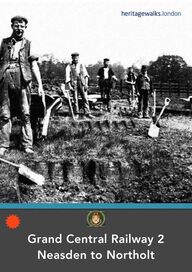
Grand Central Railway Walk Part 2 Neasden to Northolt First published in the UK in 2016 Text and images copyright © Michael Strachan Michael Strachan has asserted his rights to be identified as the author of this work in accordance with the Copyright, Designs and Patents Act, 1988. All rights reserved. No part of this publication may be reproduced, stored in a retrieval system, or transmitted, in any form or by any means, electronic or mechanical, by photocopying, recording or otherwise, without prior permission in writing from the publisher. (The cover illustration shows a GCR Railway Turf-cutting gang)
Contents Interactive ipointr Guides 3 Contents 4 Origins of the Neasden to Northolt line 5 Marylebone to Wembley 7 Neasden Junction 8 Oakington Manor 10 The men and the Machinery (and the Animals!) 11 ‘The Great Tower of Wembley’ 12 British Empire Exhibition 14 Wembley Stadium 15 The First Match at the Stadium 16 Wembley Stadium Station 17 Wembley High Road & Harrow Road 18 The Harrow Road 20 Sudbury & Harrow Road Station 21 Sudbury to Harrow 22 Sir William Perkin 23 Harrow Road to Sudbury Hill Station 24 Sudbury Hill & Wood End to Northolt 26 THE GRAND CENTRAL RAILWAY WALK PART 2 WEMBLEY TO NORTHOLT 3Tap or scan any red/white icon like the one shown here… …to access a ‘What3Words’ location. To find out more about using ‘What3Words’ click here…
In a 1950s pamphlet the origin of the Great Western and Great Central Joint Railway is described as going ‘…back to the latter part of the 1870's, when the Manchester, Sheffield and Lincolnshire Railway realised that, if it were to survive …it would have to bring its own traffic south and into London over its own metals… the Manchester Sheffield and Lincolnshire found that they were just "collectors" for other larger Companies like the Great Northern, Midland, and London and North Western Railways. After several years of indecision the plunge was taken, and in 1893 an Act of Parliament was obtained, authorising the construction of the Manchester Sheffield and Lincolnshire Railway's line southwards from Annesley, through Nottingham, Leicester, and Rugby, finally linking up with the Metropolitan Railway's northern extension, which had by this time reached Quainton Road in Buckinghamshire. From here it was proposed that running powers should be obtained to Canfield Place (now known as Finchley Road), whence a short line would be projected to an entirely new London terminus at Marylebone.’ Being such a latecomer to the national railway system, this extension had to carve a new route through the countryside as many of the best routes had already been taken by other railway companies. High embankments were to be built, cuttings excavated and sites crossed either by viaduct or tunnel.THE GRAND CENTRAL RAILWAY WALK PART 2 WEMBLEY TO NORTHOLT 4This full text of this pamphlet can be read by following this link… Origins of the Neasden to Northolt lineBack to contents…
The map below shows how, after Neasden, the GCR line branched off to Sudbury and Harrow Road station, before joining the line from Paddington at Northolt, (shown by the red circles). After Wembley Hill the line passed through South Harrow and on to Northolt. South Harrow appears twice on this map - once on the GCR extension line but also on the line from Rayner’s Lane to Sudbury Hill and Sudbury Town - now part of the Piccadilly line. Wikipedia only states: ‘On 20 November 1905 the Great Central Railway opened a new route for freight trains between Neasden Junction and Northolt Junction. Passenger services from Marylebone began on 1 March 1906, when three new stations were opened: Wembley Hill, Sudbury & Harrow Road and South Harrow. On 2 April 1906 these services were extended to Northolt Junction.' So the ‘mystery’ remains! THE GRAND CENTRAL RAILWAY WALK PART 2 WEMBLEY TO NORTHOLT 5Nothing much can be seen of this route between Marylebone and Wembley - but there is much of historical interest. The walking route starts from Wembley Stadium Station, so we begin by taking the Chiltern Line train from Marylebone Station.Back to contents…
At Marylebone Station take a Chiltern Line train to Wembley Park station… The early history of Marylebone is tied into the Great Central Railway (GCR)'s extension into London. When Sir Edward Watkin became chairman the approach to Marylebone was the last section of the Great Central Main Line to be built. Progress was delayed because of objections, particularly as the line would pass through Lord's, the home of Marylebone Cricket Club. Watkin promised no disruption by the railway construction, and a cut-and-cover tunnel constructed between September 1896 and May 1897, avoided the cancellation of any cricket. However more than 4,000 working-class people were evicted from their homes to turn Harewood Avenue and Rossmore Road into approach roads. The station opened to passengers in 1899.THE GRAND CENTRAL RAILWAY WALK PART 2 WEMBLEY TO NORTHOLT 6Marylebone Station entranceMarylebone to WembleyThe walking routeBack to contents…
GCR bridge over main line from Euston This bridge can be seen from the Chiltern and Metropolitan Line trains as they pass under the North Circular Road, but its original structure is now obscured by later installed safety panelling. Neasden North signal box Nov. 1905 Neasden GCR sidings looking towards MaryleboneThe Chiltern Line service to Wembley Stadium and beyond covers a section of the old GCR route and you should look out for some of the bridges and viaducts that still remain from the original construction. As you reach Neasden, (without stopping at the station)… …you are passing through or near to the old railway yards and sidings. This large area is now almost completely occupied by warehouses and superstores. It’s only when you get near to Wembley Stadium station that it’s possible to properly match up the old photographs with their present day locations. However, we have included some photos of this section taken during the construction.THE GRAND CENTRAL RAILWAY WALK PART 2 WEMBLEY TO NORTHOLT 7112233The Great Central Railway established its depot and sidings here, with a six line shed built of brick which was there until closure in 1962.!Much of the site was then re-developed commercially.Back to contents…Neasden Junction
!!Neasden junction in 1959 Up empty Cup Final special local at Neasden Junction. View westward, towards Northolt Junction, Harrow-on-the-Hill - and Wembley Stadium A Suburban tank engine No. 67781 at the coaling plant, Neasden Shed. One of many Thompson L1 2-6-4T's working in the 1950's on the Marylebone - Princes Risborough/Aylesbury services before the introduction of diesel multiple-units.This bridge over the River Brent can still be seen, but only by taking a long diversion from the North Circular Road to a point about half way along the Great Central Way…Ben Brooksbank!/!A Suburban tank engine at Neasden Shed, getting attention!/!CC BY-SA 2.0Ben Brooksbank!/!Creative Commons Attribution Share-alike license 2.0!/!CC BY-SA 2.0112233THE GRAND CENTRAL RAILWAY WALK PART 2 WEMBLEY TO NORTHOLT 8Back to contents…
Oakington Manor Farm Wembley, at the time of Neasden & Northolt construction c 1905 Now long since built over.Loco 15 - Oakington Manor Farm cuttingTHE GRAND CENTRAL RAILWAY WALK PART 2 WEMBLEY TO NORTHOLT 9'Blind Lane' 1902The name Oakington does not derive from some historic tree but from ‘the farm of the sons of Toca’ - first mentioned in 1171. The Great Central Railway line ran across the north of the farm in 1906 and the Lord of Tokyngton manor, Sir Audley Neeld, entered into an agreement with Wembley council to develop a ‘garden city’ estate of semi-detached houses in 1913. The estate was the borough’s first exercise in town planning and is now a conservation area.Oakington ManorBack to contents…
The Men, the Machinery (and the Animals!) These illustrations show the heavy steam excavation equipment used on the Oakington Manor and Wembley cuttings. The spoil was dropped into rail wagons running on a small gauge railway that can be seen below. Removal was horse-powered! The ‘Navvies’ who posed for the photo were turf cutters and at least one of them has an army belt on suggesting that he may have been ex-soldier. THE GRAND CENTRAL RAILWAY WALK PART 2 WEMBLEY TO NORTHOLT 10Turf-removing gang - Wembley park 1902Shire horse with work gangSteam ‘navvy’ in Wembley cutting and horsesLoco ‘Mersey’Train removing spoil, 1903Steam NavvyBack to contents…
‘The Great Tower of Wembley’ Before you leave Wembley Stadium Station turn back along the platform to look at the cutting… Today nothing remains to show that it was once the site of a fabulous tower and park – the inspired vision of Sir Edward Watkin. Steam ‘navvy’ Wembley cutting 1902 & Watkin’s FollySir Edward WatkinTHE GRAND CENTRAL RAILWAY WALK PART 2 WEMBLEY TO NORTHOLT 11Wembley Park Tower cutting 1905Wembley Park 1905 Tower and LakeSteam 'navvy' closeup in Wembley cuttingWatkin’s Folly first stageBack to contents…
Sir Edward Watkin (1819–1901) was a British Member of Parliament and visionary railway entrepreneur, noted for being chairman of nine different British railway companies. He began work on the construction of a channel tunnel under the English Channel, with the aim of connecting his lines to the railway network in France. He opened the Great Central Main Line, which was designed to accommodate the larger continental European trains which would cross into Britain from France. Although the channel tunnel project failed in 1881, Watkin remained a driven innovator, inspired by grand schemes such as the 'Great Tower of Wembley’. Watkin's Tower was intended to be a 358-metre (1,175 ft) iron lattice tower that would attract visitors to Wembley Park and his Metropolitan Railway. Designed to be higher than the Eiffel Tower in Paris, and higher than the modern ‘Shard’, it was never completed and it was demolished in 1907. The site of the tower is now occupied by Wembley Stadium. Watkin successfully opened the park in 1894 and built a new station at Wembley Park, but the tower ran into financial and structural difficulties. He died before it was completed and the base structure was demolished in 1907. The Channel tunnel project had been blocked by Parliament and cancelled in the interests of national security. The original entrance to Watkin's tunnel works remains at Shakespeare Cliff between Folkestone and Dover but is now closed for safety reasons. Wembley Park & Watkin’s FollyTHE GRAND CENTRAL RAILWAY WALK PART 2 WEMBLEY TO NORTHOLT 12Back to contents…
In 1920 the British Government decided to open the British Empire Exhibition at Wembley Park, on the site of the pleasure gardens created by Sir Edward Watkin in the 1890s. It was hoped that the Exhibition would strengthen the bonds within the Empire, stimulate trade and demonstrate British greatness both abroad and at home. However, Wembley Urban District Council was opposed to the idea, as was The Times, which considered Wembley too far from Central London. The Exhibition's official aim was "to stimulate trade, strengthen bonds that bind mother Country to her Sister States and Daughters, to bring into closer contact the one with each other, to enable all who owe allegiance to the British flag to meet on common ground and learn to know each other". It cost £12 million and was the largest exhibition ever staged anywhere in the world. It attracted 27 million visitors and made Wembley a household name. A purpose-built "great national sports ground", called the Empire Stadium, was built for the Exhibition.Wembley in Colour. London: Longmans, Greeen & Co., 1924: 100. Collection of the author - Anne Clendinning, “On The British Empire Exhibition, 1924-25”THE GRAND CENTRAL RAILWAY WALK PART 2 WEMBLEY TO NORTHOLT 13British Empire Exhibition 1924/5 Back to contents…
The first turf was cut by King George V, and it opened to the public on 28 April 1923. Much of Humphry Repton's original Wembley Park landscape was transformed in 1922–23 during preparations for the British Empire Exhibition of 1924–25. First known as the ‘British Empire Exhibition Stadium’ or simply ‘Empire Stadium’, it was built by Sir Robert McAlpine for the British Empire Exhibition of 1924 (extended to 1925). The stadium cost £750,000 (equivalent to approximately £46 million in 2020) and was constructed on the site of Watkin's Tower. The architects were Sir John Simpson and Maxwell Ayrton and the head engineer Sir Owen Williams. It was originally intended to demolish the stadium at the end of the Exhibition, but it was saved at the suggestion of Sir James Stevenson, chairman of the organising committee for the Empire Exhibition. The ground had been used for football as early as the 1880s. The stadium's distinctive Twin Towers became its trademark. Also well known were the 39 steps needed to be climbed to reach the Royal box and collect a trophy (and winners'/losers' medals). Wembley was the first pitch to be referred to as "Hallowed Turf". The "Wembley Stadium Collection" is held by the National Football Museum. The stadium closed and demolition commenced in December 2002, completing in 2003 for redevelopment. The top of one of the twin towers was erected as a memorial in the park on the north side of Overton Close in the Saint Raphael's Estate. Watkin’s Folly demolished and the Stadium emergesTHE GRAND CENTRAL RAILWAY WALK PART 2 WEMBLEY TO NORTHOLT 14Wembley Stadium Back to contents…
The first event at the stadium was the FA Cup Final on 28 April 1923 between Bolton Wanderers and West Ham United. This is sometimes called the White Horse Final. So eager were fans and casual observers to attend the final at the new national stadium that vast numbers of people crammed through the 104 turnstiles, far exceeding its official 127,000 capacity. Estimates of the number who came range from 240,000 to well over 300,000. It was thought that the match would not be played because so many spectators had spilled onto the pitch. That was until mounted police, including Police Constable George Scorey and his white horse, Billy, slowly pushed the crowds back to the sides of the field of play for the match to start, just 45 minutes late. In honour of Billy, the footbridge outside the new Wembley Stadium has been named the White Horse Bridge. The match was a 2–0 victory for Bolton Wanderers, with David Jack scoring the first ever goal at Wembley. Wembley Stadium - First FA Cup 1923THE GRAND CENTRAL RAILWAY WALK PART 2 WEMBLEY TO NORTHOLT 15The First Match at the StadiumBack to contents…
The first station to bear the name Wembley Stadium, about one-half mile (800!m) east-north-east of the present station, was opened by the LNER (London and North Eastern Railway) on 28 April 1923 as The Exhibition Station (Wembley). It had one platform, and was situated on a loop which forked off the Chiltern Main Line between Neasden Junction and Wembley Hill station (now Wembley Stadium station.INTERIOR DESIGN quisque eget aliquam p. 16THE GRAND CENTRAL RAILWAY WALK PART 2 WEMBLEY TO NORTHOLT 16Wembley Stadium Station & White Horse BridgeWembley Hill Station under constructionWembley Hill Station footbridgeWembley Hill Station bridge completed 1905.Wembley Stadium Station We now come to the main walking route. To remind yourself of what this looks like either go back to page 6 or click here…Back to contents…
THE GRAND CENTRAL RAILWAY WALK PART 2 WEMBLEY TO NORTHOLT 17Wembley High Road & Harrow RoadExit Wembley Stadium station… Turn left along Wembley Hill Road and cross over into Ecclestone Place… At the end of Ecclestone Place turn left down to Wembley High Road… Turn right along this shopping high street, past Wembley Central Station on your left… …until it becomes Harrow Road again and you will see the church of St John the Evangelist on your right… St John the Evangelist Church was designed by Gilbert Scott and built in 1846, when Wembley became a separate parish. This was mainly the work of the Copland sisters - Anne and Frances - who inherited Sudbury Lodge and its estate in 1843. They offered land nearby for a church to serve the southern part of Harrow parish. In spite of opposition from local farmers, who preferred a site on Lord Northwick’s property on Wembley Hill, the sisters’ offer was accepted since they would bear all the cost of building. St John the Evangelist church was built of flint with stone dressings with nave, chancel, north-east chapel and wooden bell turret. Back to contents…Harrow Road leading up to Wembley Hill Road c 1960sSt John’s Church during construction period and (below)
THE GRAND CENTRAL RAILWAY WALK PART 2 WEMBLEY TO NORTHOLT 18Continue along Harrow Road and turn right into Crawford Avenue… Follow Crawford Avenue around to the left up to Harrowdene Road… As you turn briefly up this road you’re entering the Harrowdene Estate built in the early twentieth century. The railway bridge ahead of you, (shown opposite), was constructed to carry the GCR line. Return to Crawford Avenue and turn right to walk down to the Harrow Road… Turn right and walk on keeping Barham Park on your right…Back to contents…Harrowdene Road bridge and Estate siteHarrowdene Road GCR bridge‘Barham Park was formed from the grounds of the 18th century Crab's House, named after the family who had it in the 1790s, but later called Old Barham Court. John Copland purchased it in 1801 and in c.1850 built Sudbury Lodge, later called Barham Mansion. Anne Copland (d.1872) and her sister Frances (d.1870) who inherited the estate on their father's death, founded a village hospital and supported much of the development of Wembley. From about 1880 it was the home of Sir George Barham, founder of the Express Dairy, who acquired the remainder of Sudbury Park in 1895 after the death of General Copland-Crawford. Barham's son, Titus, inherited the estate when his father died in 1913, and spent much on its improvement but died in 1937, leaving Barham Mansion, his private museum and its grounds to the citizens of Wembley.
THE GRAND CENTRAL RAILWAY WALK PART 2 WEMBLEY TO NORTHOLT 19Continue along the Harrow Road past the major roundabout and around the junction to where you can see the GCR bridge… The postcard view opposite shows the rural view of this road during the period between the two World Wars. It was the terminus for the tram service which would soon give way to the trolleybus.Back to contents…Harrow Road to SudburyThe photo opposite shows the same view of Harrow Road and was taken at the beginning of the nineteenth century during construction of the `Neasden to Northolt’ extension… The raised decoration on the ironwork was a feature of many of the bridges – as you saw on the Harrowdene bridge.Today the bridge is st ill here but has lost its distinctive ironwork decoration. The number 18 bus service from Paddington travels the length of the Harrow Road and ends here just like the trams and trolleybuses.
THE GRAND CENTRAL RAILWAY WALK PART 2 WEMBLEY TO NORTHOLT 20Walk under the bridge and the station is immediately on your left… There is almost nothing of the original station part from a blocked doorway on the right. The station is unmanned so you can go up to the platform – just follow the entrance directions taking you under the railway and up to the single platform. The photo opposite shows the view from the platform towards Ruislip and Northolt and the present day footbridge.Back to contents…Sudbury & Harrow Road StationReturn to the Harrow Road and turn left, walking up to Sudbury Crescent… Walk to the end of this crescent to reach Perkin Close where you turn left into a narrow passageway leading up to the footbridge… Do have a look from the top at the passing trains.The photo shown above is of the original footbridge taken during the construction of the line that was replaced by the modern version shown right… Return to Perkin Close and follow this passage back to the Harrow Road…
THE GRAND CENTRAL RAILWAY WALK PART 2 WEMBLEY TO NORTHOLT 21As you reach the Harrow Road the Swan pub is immediately on your left… The building is shown as it looks today, (left) and below how it looked back in the early twentieth century.Back to contents…Sudbury to Harrow on the HillContinue along the Harrow Road to the left of Butler’s Green to the Methodist Church shown below… This church has a small brick stand and noticeboard at the front showing on its side a plaque commemorating the famous Industrial chemist Sir William Perkin. There is also a short biography on the back of the plinth placed there by the Wembley Historical Society. (See panel below right).‘In 1859 William Henry Perkin came to live in Sudbury. Two years after the 1874 sale of his famous Perkin & Sons dye works, he built a new home 120 yards west of here which he named ‘The Chestnuts’ where he lived and worked for 31 more years. This plaque was unveiled in 2006 by a Master Leatherseller to celebrate the centenary of Perkin’s 1906 Knighthood & other honours, including a Mastership of The Leathersellers’ Company.’
THE GRAND CENTRAL RAILWAY WALK PART 2 WEMBLEY TO NORTHOLT 22Sir William PerkinSir William Perkin was born in the East End of London, the youngest of the seven children of George and Sarah Perkin. At the age of 14, Perkin attended the City of London School, and was taught by Thomas Hall, who encouraged him to pursue a career in chemistry. In 1853, at the age of 15, Perkin entered the Royal College of Chemistry in London (now part of Imperial College London), where he began his studies under August Wilhelm von Hofmann. Having become one of Hofmann's assistants, Perkin began a series of experiments to synthesise quinine, an expensive natural substance much in demand for the treatment of malaria.During the Easter vacation in 1856, Perkin performed some further private experiments in the crude laboratory in his apartment on the top floor of his home in Cable Street in east London. Here he made his great accidental discovery. He found that aniline could be partly transformed into a crude mixture which produced a substance with an intense purple colour. This achievement is now marked by the plaque shown below. Perkin named the colour mauve and the dye mauveine and marketed his discovery instead of returning to college. Perkin’s father used his own savings to build a factory at Greenford Green, near Harrow. By December 1857, Perkin and Sons began supplying mauve to silk dyers and his fortune was made.. He went on to work on other aniline-based dyes, including a synthetic version of alizarin, a red dye extracted from the madder plant. His company continued to be so successful that in 1874, at the age of only 36, he was able to sell the factory and retire from industry, devoting his time to carrying out research at home. The photo above shows ‘The Chestnuts’ – the home he built which is sadly now demolished.Back to contents…
THE GRAND CENTRAL RAILWAY WALK PART 2 WEMBLEY TO NORTHOLT 23Turn left along the last part of the Harrow Road and continue until you see St Andrews Church on your right… This takes us away from the route of the GCR extension line for a while towards Harrow on the Hill. The church of St Andrew shown right was built in 1926 and retained the earlier mission building as its church hall. The original GCR photographer would not have seen this building but it is Grade II listed.Back to contents…Harrow Road to Sudbury Hill StationContinue up the Harrow Road until you see St George’s Roman Catholic Church on your right… This church was established by Cardinal Bourne to serve what was then still a rural area. The architect was James Leonard Williams who designed it in an English Gothic perpendicular style to be built in brick and stone.As you continue along the Harrow Road you’ll see these buildings on your left… The four cottages shown here are about 200 years old. The first is called Chester Lodge. The large, black-painted double doors in the centre opened up to a yard behind the cottages, which in Victorian times may have been used by a wheelwright’s business.
THE GRAND CENTRAL RAILWAY WALK PART 2 WEMBLEY TO NORTHOLT 24Continue along the last part of the Harrow Road… Across the road you will see the ‘Black Horse’ pub, dating back to at least 1751, when a Sarah Howard was the innkeeper. In 1786, a traveller who crossed Sudbury Common to lodge at this pub, was attacked by highway robbers (they were later caught, tried and hanged).Back to contents…Carry on up the Harrow Road to the roundabout and turn left down the Greenford Road to rejoin the GCR route… Although it is off the GCR route, the original photographer must have diverted up to Harrow on the Hill to view the Parish Church of St Mary and Harrow School. Two colourised versions of his original photos are shown here.You can divert to the pretty village of Harrow on the Hill from this roundabout up Sudbury Hill, but it’s a long diversion and it is covered in another of our walks. The view shown right is of the old Harrow school. The church stands at the top of the slope. Continue down the Greenford Road until you reach the Rising Sun pub…
THE GRAND CENTRAL RAILWAY WALK PART 2 WEMBLEY TO NORTHOLT 25This is the Rising Sun pub at the time of the GCR extension construction. The original cameraman clearly liked to go off route in search of interesting pubs and churches. The photo below shows how it looks today – no ‘improvements’ can be seen.Back to contents…Walk on further down the Greenford Road to pass Sudbury Hill station on your right… This is an unmanned standard halt station with mostly non-stopping trains passing through at high speed. There are just a few local trains which will take you through to Northolt Park (similarly unmanned) or back to Wembley.There is very little of interest between Sudbury Hill and Northolt so we recommend crossing this area using local bus services. Routes 92 or 395 will take you to Northolt Village in just a few minutes… The only GCR feature in this area is the cut and cover tunnel entrance at Wood End shown on the right and below…Sudbury Hill & Wood End
Having arrived near Northolt Station follow Mandeville Road and turn left into Ealing Road… Look for the distinctive village clock erected in 1937 to commemorate the coronation of King George VI. The conservation area description says it is "of rustic appearance, an oak frame with brick infill and a tiled roof surmounted by a delightful copper wind vane".THE GRAND CENTRAL RAILWAY WALK PART 2 WEMBLEY TO NORTHOLT 26The modern photo on the previous page was taken from Bridge D4 at Wood End Road near Ross Close. The other GCR photos on this page were taken during the original construction.Back to contents…These two photos (also shown earlier) picture a gang of men (and boys) excavating the cutting before laying the line and covering the tunnel at Wood End.
THE GRAND CENTRAL RAILWAY WALK PART 2 WEMBLEY TO NORTHOLT 27The clock tower plaque is shown here… ‘This clock was erected by the citizens of Ealing to commemorate the coronation of their majesties King George VI and Queen Elizabeth. Mayor Councillor F. F. Woodward J.P. Chairman of Highways Committee Alderman A. W. Bradford May 1937’Back to contents…As you walk down Ealing Road you enter a delightful series of gardens with some beautiful trees… The handsome pub on your right is ‘The Crown’ and, if you turn away from this alluring prospect, you will see St Mary’s Church framed by some magnificent oaks.‘A priest is recorded at Northolt in 1086 and the church formed part of the endowment of Walden Abbey (priory), founded by Geoffrey de Mandeville in 1140. It was built around 1290 and was expanded over the centuries, with the chancel being added in 1521, the spired bell tower in the 16th century, and a gallery at the west end of the church in 1703. The internal beams are original and the bells date from the 17th century.’
THE GRAND CENTRAL RAILWAY WALK PART 2 WEMBLEY TO NORTHOLT 28Just beyond the church is a path leading to a beautiful flowering meadow… Do look out for the notice boards that describe the church building and tell of human settlements here since the Iron Age. This beautiful church with its surrounding woods, gardens and fields forms part of the Northolt and Greenford Countryside Park created by local inhabitants and Ealing Council.Back to contents…The GCR photographer took the above picture of the church. As you retrace your steps back to Ealing Road… Look out to your right for the two buildings forming Willow Cottages (shown above right). These were occupied until World War Two by large families and are now maintained to show how life was for the rural poor. Continue along Ealing Road and cross over to Northolt station where this walk ends…
If you have enjoyed this digital guide...
...please consider donating a reasonable amount by scanning or tapping the QR code below and
following the instructions.
Your contribution will help us to continue developing and designing our walks and will be greatly appreciated.
Contact Us send