Return to flip book view
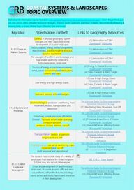
Welcome! All information can be found on www.geographyportal.co.uk/coastalsystemslandscapes . Don’t forget there you can also access Ultra-‘Detailed Resource Packages,’ Practice Exam Questions, Exemplar Answers, Recommended Reading & Viewing Links, a coasts Online Topic Checklist Test and more! Key Idea: Specification content: Links to Geography Resources: 3.1.3.1 Coasts as Natural Systems Systems in physical geography: system concepts and their application to the development of coastal landscapes L1 | Introduction to CS&P Powerpoint | Worksheet Inputs, outputs, energy, stores/components, flows/transfers, positive/negative feedback, dynamic equilibrium. L1 | Introduction to CS&P Powerpoint | Worksheet The concepts of landform and landscape and how related landforms combine to form characteristic landscapes L1 | Introduction to CS&P Powerpoint | Worksheet 3.1.3.2 Systems and Processes Sources of energy in coastal environments: winds, waves (constructive and destructive), currents and tides. L2 | Energy In Coastal Environments Powerpoint | Worksheet L4 | Tides, Currents & Storm Surges Powerpoint | Worksheet Low energy and high energy coasts. L3 | Low & High Energy Coasts Powerpoint | Worksheet L4 | Tides, Currents & Storm Surges Powerpoint | Worksheet Sediment sources, cells and budgets. L3 | Low & High Energy Coasts Powerpoint | Worksheet Geomorphological processes: weathering, mass movement, erosion, transportation and deposition The Ultimate Guide To Geomorphological Processes Resource Package L7 | Weathering, Mass Movement, Run-Off Powerpoint | Worksheet Distinctively coastal processes of Marine Erosion: hydraulic action, wave quarrying, corrasion/abrasion, cavitation, solution, attrition, run-off The Ultimate Guide To Geomorphological Processes Resource Package L5 | Processes & Landforms of Erosion Powerpoint | Worksheet L10 | Erosion & Factors Affecting Erosion Powerpoint | Worksheet Transportation: traction, suspension , longshore/littoral drift. The Ultimate Guide To Geomorphological Processes Resource Package L6 | Transportation & Deposition Powerpoint Ero/Deposition: sub-aerial weathering, mass movement and run-off (both erosional and depositional) The Ultimate Guide To Geomorphological Processes Resource Package L6 | Transportation & Deposition Powerpoint 3.1.3.3 Coastal Landscape Development This content must include study of a variety of landscapes from beyond the United Kingdom (UK) but may also include UK examples. SEE 3.1.3.6 > Case Studies Origin and development of landforms and landscapes of coastal erosion: cliffs and wave cut platforms, cliff profile features including caves, arches and stacks; factors and processes in their development. The Ultimate Guide To Geomorphological Processes Resource Package L10 | Erosion & Factors Affecting Erosion Powerpoint | Worksheet
Coastal Deposition: Beaches, simple and compound spits, tombolos, offshore bars, barrier beaches and islands and sand dunes. The Ultimate Guide To Geomorphological Processes Resource Package L11 | Dunes, Marshes, Mudflats, Sea Level Change Powerpoint Estuarine mudflat/saltmarsh environments and associated landscapes; factors and processes in their development. L11 | Dunes, Marshes, Mudflats, Sea Level Change Powerpoint Eustatic, isostatic and tectonic sea level change: major changes in sea level in the last 10,000 years. L11 | Dunes, Marshes, Mudflats, Sea Level Change Powerpoint Coastlines of emergence and submergence. Sea Level Changes Over Time & Their Landforms Resource Package Origin and development of associated landforms: raised beaches, marine platforms; rias, fjords, Dalmatian coasts. Sea Level Changes Over Time & Their Landforms Resource Package Recent and predicted climatic change and potential impact on coasts. L14 | Climate Change & Sea Level Rise Powerpoint | Worksheet The relationship between process, time, landforms and landscapes in coastal settings. None At Present (10.01.21) 3.1.3.4 Coastal Management Human intervention in coastal landscapes [Nature Of SMP – Shoreline Management Plans] L15 | Coastal Management Strategies Powerpoint | Worksheet 2019 Government National SMP Strategy Traditional approaches to coastal flood and erosion risk: hard and soft engineering. L15 | Coastal Management Strategies #2 Worksheet Sustainable approaches to coastal flood risk and coastal erosion management. The Netherlands 🔺 Further Example Integrated coastal zone management [ICZM] The Netherlands 🔺 Further Example 3.1.3.5 Quantitative and Qualitative Skills Students must engage with a range of quantitative & relevant qualitative skills. N/A 3.1.3.6 Case studies of Coastal Landscapes Case study of a coastal environment at a local scale to illustrate and analyse fundamental coastal processes, their landscape outcomes as set out above and engage with field data and challenges represented in their sustainable management. L16 | Holderness Coastline Powerpoint | GeoFile #141 | Overview Lyme Regis 🔺 Further Example Case study of a contrasting coastal landscape beyond the UK to illustrate and analyse how it presents risks and opportunities for human occupation and development and evaluate human responses of resilience, mitigation and adaptation. L16 | Sundarbans Delta, Bangladesh Powerpoint | Worksheet L17 | Sundarbans Opportunities/Challenges Powerpoint The Netherlands 🔺 Further Example The A Level Maps Page is available on the Geography Portal. It is an interactive system which allows you to navigate the world and view our recommended A-Level human and physical Case Studies (with their own tailor-made Case Study Fact Files) as well as A* Case Studies, for students aiming for the top grades, and extra learning Further Examples!
Key Term: Explanation: System A natural or human system is an assemblage of interrelated parts that work together by way of some driving process. Systems are often visualized or modelled as component blocks that have connections drawn between them Positive/Negative Feedback Positive feedback loops enhance or amplify changes; this tends to move a system away from its equilibrium state and make it more unstable. Negative feedbacks tend to dampen or buffer changes; this tends to hold a system to some equilibrium state making it more stable. Dynamic Equilibrium. A state of balance between continuing processes (e.g. inputs and outputs in a system) When one changes, another is simultaneously altered. Constructive / Destructive (Waves) Constructive waves are flat and low in height and have a long wavelength. Their strong swash ‘builds up the beach.’ The wave energy dissipates over a wide area which results in a weak backwash. Destructive waves have a large wave height and short wavelength. They have tall breakers that have a high downward force and a strong backwash. Their strong downward energy helps erode beach material and cliffs. This leads to narrow beach profiles. Currents An ocean current is a continuous, directed movement of sea water generated by a number of forces acting upon the water. Tides Tides are the rise and fall of sea levels. Tides are caused by the gravitational pull of the moon and to a lesser extent the sun. Sediment Source This describes the different points of origination for sediment in a coastal landscape. They can include weathering, longshore / littoral drift, erosional processes and river outflow. Sediment Cell Sediment cells are areas along the coastline and in the nearshore area where the movement of material is largely self-contained. They can be considered as a closed coastal sub-system. Sediment Budget A sediment budget is the balance between changes in the volume of sediment held within the system and the volume of sediment entering or leaving the system. These can be in surplus (positive) or deficit (negative). Geomorphological Geomorphology is the study of landforms, their processes, form and sediments at the surface of the Earth. Study includes looking at landscapes to work out how processes such as air movement, water and ice, can mould the landscape. Hydraulic Action Process of erosion which occurs where the power of waves hits a cliff face directly and gradually breaks down the rock material, with high pressure water being forced into narrow crevices in the rock. Wave Quarrying This is a shortened process of Hydraulic Action, where high energy, tall waves hit the cliff face and have the power to remove large chunks of rock in one go through the sheer force of the wave. Corrasion / Abrasion Erosional process when rocks and other materials carried by the sea are picked up by strong waves and thrown against the coastline causing more material to be broken off and carried away by the sea. Cavitation Compression of air in sea-facing joints as waves crash against cliffs can cause sea water to be severely compressed. As the wave recedes the pressure reduces and air comes out of solution in violent 'fizzing', growing cracks and speeding up rock erosion. Solution Erosional process by which carbonic acid in seawater dissolves rock at the coastline and breaks it down (particularly rock types containing calcium carbonate such as limestone and chalk.) Attrition Erosional process where rocks and boulders are ground over each other in the water –repeated swash and backwash - and over time become smoothed. Boulders/fragments become pebbles, pebbles become shingle, and shingle may become sand.
Traction Form of transportation by which pebbles and larger sediment are rolled along the seabed. Suspension A process of material transportation involving small particles being carried in water, such as silts and clays, which can make the water look cloudy. Longshore / Littoral Drift When waves approach the coastline at an angle as a result of the wind driving them onwards at the same angle. Waves push material at an angle up the beach via the swash and it is then deposited on the beach. The backwash will then collect the material and pull it down the beach in a vertical direction back out to sea. Another wave will then collect that material and carry it obliquely towards shore again. Best way to show this is visually! Sub-Aerial Weathering Sub-aerial processes refer to the processes of weathering and mass movement. Weathering is the breaking down of rock in situ. It can be divided into mechanical (e.g. freeze-thaw, biological) and chemical weathering (e.g. through acidic precipitation). (Sub-Aerial) Mass Movement Sub-aerial processes refer to the processes of weathering and mass movement. This refers to the movement of material downslope under the influence of gravity. Run-off When rivers & streams erode away their channel as they approach the mouth. Increased erosion of coastal landscapes can occur because of this. Often, at river estuaries there is an increase in coastal deposition as the river current entering the sea increases turbulence and friction with marine currents, reduces the energy of both. Simple / Compound Spit Simple spits are relatively straight forms extending into deeper water from a headland. Compound spits possess several recurves or hooks. Best way to show this is visually! Tombolo A tombolo is simply where a spit ends up joining an island on one side and a landmass on the other. Sometimes a tidal lagoon will form behind the tombolo. See images here: https://en.wikipedia.org/wiki/Tombolo Offshore Bar An offshore bar is a ridge of deposited material and sediment which can be found lying away from and parallel to a coast, deposited before waves reach land due to high friction on a very gently sloping coast. Barrier Beach / Island Barrier Beaches are narrow beaches situated parallel to the shoreline. Provides a barrier to wetlands or lagoon behind it. Very similar to a tombolo but due to wave deposition, not longshore drift. If this takes place out to sea by up to a few miles, it may form an unconnected island, very similar to an offshore bar (but larger and often vegetated.) Sand Dune Sand dunes are small ridges or hills of sand found at the top of a beach, above the usual maximum reach of the waves. Form from wind-blown sand that is initially deposited against an obstruction such as a bush, driftwood or rock. Best way to show this is visually! Estuarine Mudflat / Saltmarsh These form within the shelter of estuaries or natural harbours, where fine silt and clay sediments carried in by the gentle inward movement of the tides (and in estuaries the slow outward flow of the river) settle. They are often exposed at low tides and under shallow water at high tides. A fantastic resource link from the Wildlife Trust! Eustastic / Isostatic ( Sea Level) Eustatic change is when the sea level changes due to an alteration in the volume of water in the oceans or, alternatively, a change in the shape of an ocean basin. Isostatic sea level change is the result of an increase or decrease in the height of the land. Isostatic change is a local sea level change whereas eustatic change is a global sea level change. Tectonic (Sea Level) Unlike Eustatic and Isostatic sea level change, this one as implied is due to the tectonic movement of plates (see natural hazards) raising and lowering water levels and volume in certain places. Emergence / Submergence (Coastlines) Submergent coastlines are stretches along the coast that have been flooded by the sea by a relative rise in sea levels from either isostacy or eustacy. Submergent coastline are the opposite of emergent coastlines, which have experienced a relative fall in sea levels. Both result in unique landforms, also. Ria A submergent landform wherein a river valley has been flooded by the eustatic rise in sea level. They’re almost exactly like a typical river valley but they have even more water in them
Fjord Also a submergent landform. These are steeper and deeper variants of rias that are relatively narrow for their size. They have a u-shaped cross profile as they are flooded glacial valleys. Dalmatian Coastline These form in areas of the world where valleys lie parallel to each other. When the valleys are flooded by the rise in sea level, the tops of the valleys remain above the surface of the sea and appear to be a series of islands that run parallel to the coastline. The best example of a dalmatian coastline is the one from which they get their name, the Dalmatian coast in Croatia. SMP (Shoreline Management Plan) A Shoreline Management Plan (SMP) is a large-scale assessment of the risks associated with coastal processes and helps reduce these risks to people and the developed, historic and natural environments. Link to the 2019 Government SMP. Hard / Soft Coastal Engineering Soft engineering defines coastal engineering solutions forming natural defences, whereas hard engineering focuses on man-made or artificial barriers to prevent or mitigate coastal processes taking place. ICZM (Integrated Coastal Zone Management) A resource management system following an integrative, holistic approach and an interactive planning process in addressing the complex management issues in the coastal area. Quantitative A term used to relate to data which is measuring or measured by the quantity of something rather than its quality. Think values such as height, weight etc... Qualitative A term used to relate to data which is measuring or measured by the quality of something rather than its quantity. Think statements such as blonde, brown, red etc... as colours as opposed to their exact HEX / RGB values Last Updated: 10/01/21 © L. Pearson unless explicitly mentioned otherwise | A-Level CS&L Topic Overview V1.6 www.geographyportal.co.uk