Return to flip book view
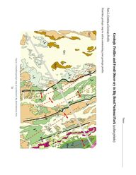
Message 74 Name: _______________________________________ Geologic Profiles and Fossil Discovery in Big Bend National Park (color prints) Part 2: Creating a Geologic Profile Print this geologic map to aid in constructing your geologic profile. Figure 1 Simplified geologic map of southeastern Big Bend National Park.
75 Page left blank intentionally.
76 Quick reference key for included geologic map. Figure 2 Color scheme and geologic map symbols for rock outcrops in Big Bend National Park. Qa1 and Qa2 are varying age alluvium deposits from the Quaternary. Tib and Tir represent Neogene through Paleogene aged basaltic- and rhyolitic- type magmatic intrusions, and Kj through Kbe are all late Cretaceous (with Javelina Formation youngest and Ernst Member oldest) predominantly sedimentary rock units.